
Walking an Englewood Street from Address to Record
An address-first street directory starts with the exact number and unit. Normalize the delivery label with USPS, then use Arapahoe County’s structured parcel search. The returned PIN or AIN creates the bridge to tax, map, and recording systems. GIS confirms the parcel’s jurisdiction and nearby geometry. A voter match is optional and requires four identity fields, while an older street guide may show a household for a past year. The order matters because a street name alone can return too much or select the wrong municipality.
- Check the delivery label, unit, and ZIP in the USPS address lookup; keep the postal result separate from the city line.
- Enter Number, Range, Street Name, and Unit in the Arapahoe parcel search; save the PIN, AIN, situs, and legal description.
- Use the GIS location form to inspect the parcel centroid, boundary, jurisdiction, districts, and adjacent public or common tracts.
- Search the recorder by party, grantor, grantee, legal description, date, document type, reception number, or book and page.
- For a civic match, use the county voter form only with the required first name, last name, birth date, and ZIP.
- For an older household, compare the address with a dated directory, newspaper, annual, map, or archive item.
That sequence gives each source a defined job. It avoids treating a parcel owner, an instrument party, a voter match, and a directory entry as interchangeable facts.
Arapahoe Assessor Fields Behind the Street Directory
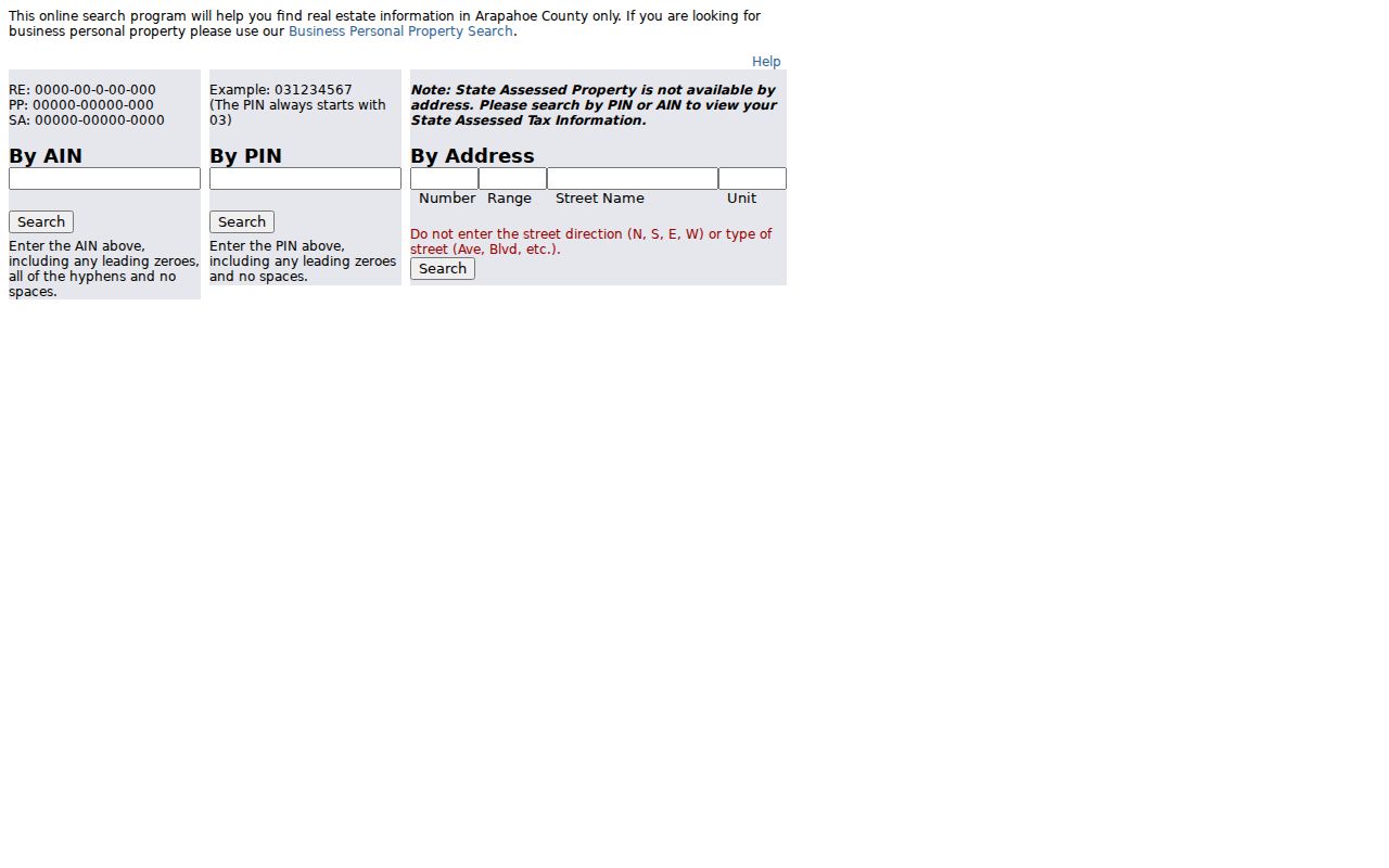
The county parcel form has no public owner-name search field. It takes a 16-character AIN, a 16-character PIN, or an address path. A PIN begins with 03 and retains leading zeroes. Address search needs Number and Range, at least three letters of Street Name, and an optional Unit. The form says to leave direction and street type out of Street Name. Six results appear per page. State-assessed property cannot be located by address, so a PIN or AIN is required for that route.
| Assessor field | Observed rule |
|---|---|
| AIN | Real-estate pattern is RE 0000-00-0-00-000; hyphens and zeroes matter. |
| PIN | Starts with 03; use numeric characters without spaces or special marks. |
| Number | Address number used with Range to avoid a whole-street result. |
| Range | Required with Number in the county’s address form. |
| Street Name | At least three letters; omit direction and street type. |
| Unit | Optional field for a supported multi-unit or suite search. |
The returned parcel can show owner and ownership type, mailing address, situs, neighborhood and code, acreage, land use, legal description, year built, building facts, values, and links to tax, sales, map, photo, and sketch material. The county warns that measurements, photos, and sketches are not guaranteed for every parcel. A searcher should record the result date and avoid calling a mailing label proof of a current household.
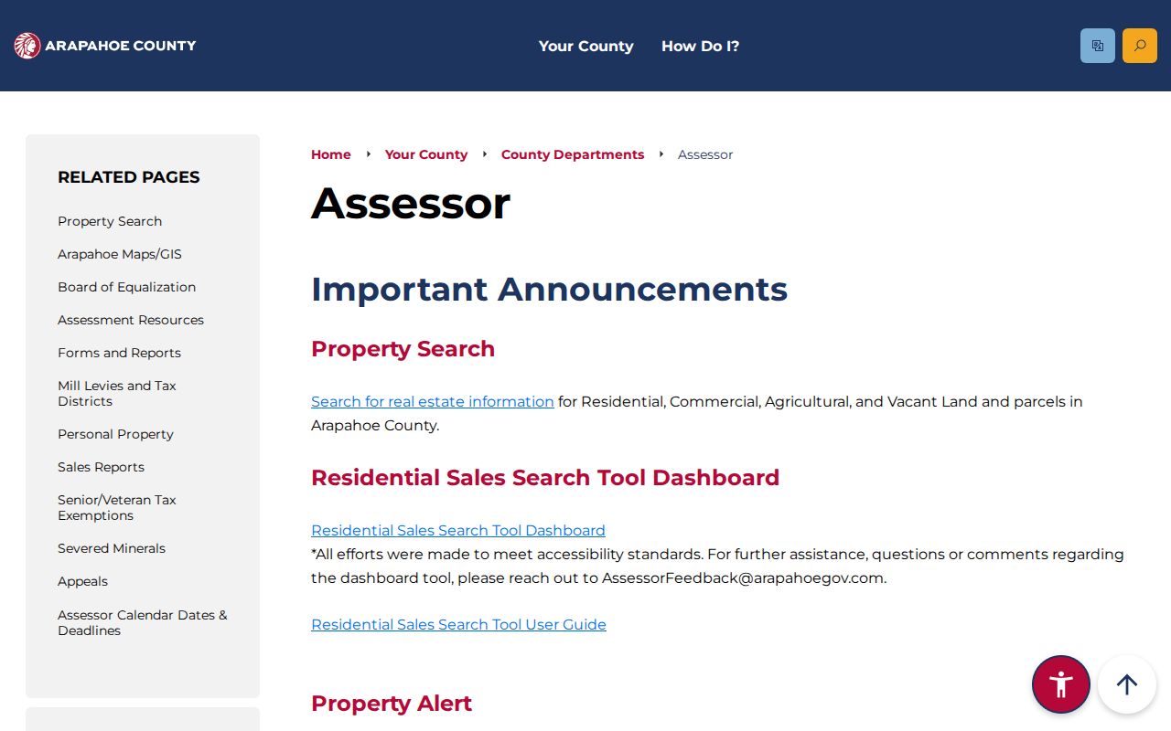
The Arapahoe County assessor research hub identifies the property-search and GIS paths used by the Englewood street directory.
The field rules become practical on the live parcel form: search the street and number first, then use the returned parcel as the stable key for the rest of the street directory.
The Arapahoe assessor parcel search is the address entry point for an Englewood street record.
Seeing an Englewood Parcel in ArapaMAP
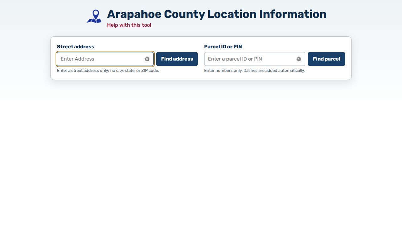
Arapahoe GIS adds the geographic check that a text result lacks. The Location Info form accepts an address or a parcel ID or PIN. It has no city, state, or ZIP inputs, and the PIN is formatted with dashes as the search proceeds. ArapaMAP layers include parcels, aerial imagery, street networks, jurisdictions, districts, planning cases, open space, and election results. Measuring, locating, redlining, and printing tools help preserve the map context.
The viewer uses a parcel centroid. A large or multipart tract may cross a boundary. A condominium or commercial property may have multiple situs addresses. The application may show a first or random assessor address rather than the one a reader expects. Record the layer name, map date, search key, and visible parcel ID. Adjacency is a geographic fact only. It does not identify a person or establish an affiliation.
The Arapahoe GIS Location Info screen is the official address and parcel route for the map portion of a street directory.
For a block-level question, turn on parcel boundaries and a relevant street or aerial layer before noting the east, west, north, and south parcels. Public roads, creeks, rail corridors, common tracts, and school or park land can appear beside a private parcel. Keep those land-use distinctions in the record.
Englewood Street Directory Coverage by Record Type
Address-keyed records overlap, but their meanings do not. This coverage table shows the route and the limit a reader should carry into the next search. Current ownership begins with the county parcel result and recorded instruments. Civic presence may be checked through Elections when the required identity match is available. City permits add a structure or project trail. Older street directories add a dated household clue.
| Record set | Keeper | What it shows | Access |
|---|---|---|---|
| Parcel and tax account | Arapahoe Assessor and Treasurer | Situs, legal parcel, physical facts, owner label, tax account route | Address, PIN, or AIN search |
| GIS parcel map | Arapahoe County GIS | Boundary, centroid, jurisdiction, districts, adjacent geography | Address or parcel/PIN |
| Recorded instruments | Clerk and Recorder | Grantor, grantee, date, legal description, liens, easements, plats | Free index; image or purchase limits |
| Voter registration | Arapahoe Elections | Matched status and possible address, party, precinct, district | Four required match fields |
| Permits and code records | Englewood departments | Project, permit, inspection, complaint, or public-writing event | iMS, Laserfiche, or focused CORA request |
| Street and reverse directories | Library and regional collections | Dated household, street, phone, or address clue | Collection, year, and access rules |
The parcel number can tie current assessment to map and tax paths. A legal description can tie the parcel to a deed or plat. A street name can help locate a directory entry. No single row supplies a complete list of people along a street.
Deeds, Easements, and Other Recorder Labels
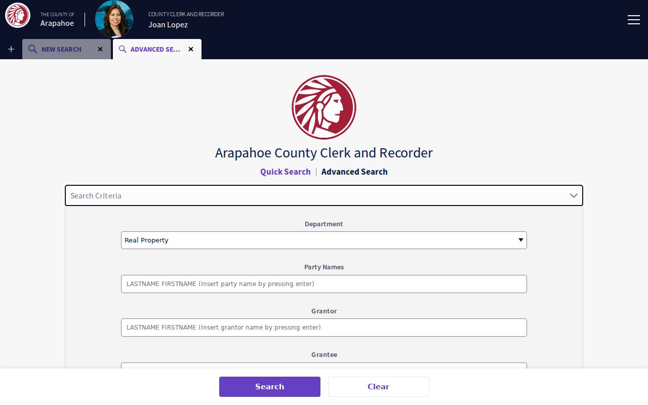
The Arapahoe recording portal’s Advanced Search exposes Party Names, Grantor, Grantee, recorded date range, document type, reception number, book, page, OCR phrase, subdivision legal, and section legal fields. Party autocomplete requires the searcher to enter the party before the portal accepts it. Quick Search also offers department, date-range presets, Index Only or Index and Full Text, reset, and Property Alert controls.
Do not stop when a street search returns no document labeled DEED. The selector includes warranty, quit claim, trustee’s, personal representative’s, beneficiary, treasurer’s, easement, covenant, plat, condominium, declaration, release, satisfaction, deed of trust, correction, lien, right-of-way, and map labels. A correction or plat may explain the parcel better than a sale instrument. Record instrument date and recording date separately when both appear.
The Arapahoe recorder Advanced Search displays the fields that make a street-level deed chain more precise.
The modern online grantor and grantee guidance is 1980 to present, while pre-1979 work may require book, page, or reception research. The main portal displayed a range beginning around 1872, and the separate QuickLink layer advertises 1860 to 1902. Treat those as overlapping access layers, not a promise that every image is online. Recording appointments and older-book questions go to the Littleton division at 303-795-4200 or recording@arapahoegov.com.
Old Englewood Names in a Modern Street Directory
Before Englewood incorporated on May 13, 1903, a future city address could appear as a rural tract, settlement, subdivision, or township and range description. Arapahoe County’s 1902 division made Littleton the county seat. Petersburg, Cherrelyn, and Orchard Place are useful historical search terms. A current street string may not match a deed, plat, directory, or newspaper from an earlier jurisdiction.
No official historic renumbering or street-change table was located in the inspected sources. The practical fallback is to compare a directory street guide, Sanborn sheet, subdivision plat, deed legal description, newspaper, city ordinance, and historic aerial. Search the modern street, an older place name, and the subdivision or block wording. Label any unresolved conversion as a research gap instead of guessing.
The public record path is available in person and by request. Ask the City Clerk, Public Works, or library archive for an address-change, plat, or map source with a date range. The county Recording Division can research older book and page material by appointment. Library microfilm, annuals, and local newspapers help identify when a name or block label changed.
Englewood Permits and Right-of-Way Clues
City permits are useful for a structure timeline, but they are not title records. Englewood’s iMS portal supports project and permit uploads, notices, payments, inspections, and communications. The public browse and historical cutoff were not fully exposed during inspection. When a guest view does not reveal a permit number, address, issue date, inspection result, or final status, send a focused CORA request to the Building Division or Public Works.
Right-of-way permits use iMS and a city permit map. The city lists a normal review interval of three to five days and routes permit questions through Public Works at 303-762-2500. Building questions go to 303-762-2357. A city record can show a project, inspection, or roadway event tied to an address. It cannot by itself establish who lived there or who held title.
City Clerk records add minutes, ordinances, planning material, code cases, and public writings. A precise request names the address or parcel, department, record type, and date window. Requests can be written, electronic, mailed, emailed, or delivered by hand. The city policy describes a three-working-day initial response, a possible seven-working-day extension, copy and research charges, a possible deposit, and a new-request treatment when the subject changes.
What an Englewood Parcel Result Can Tell You
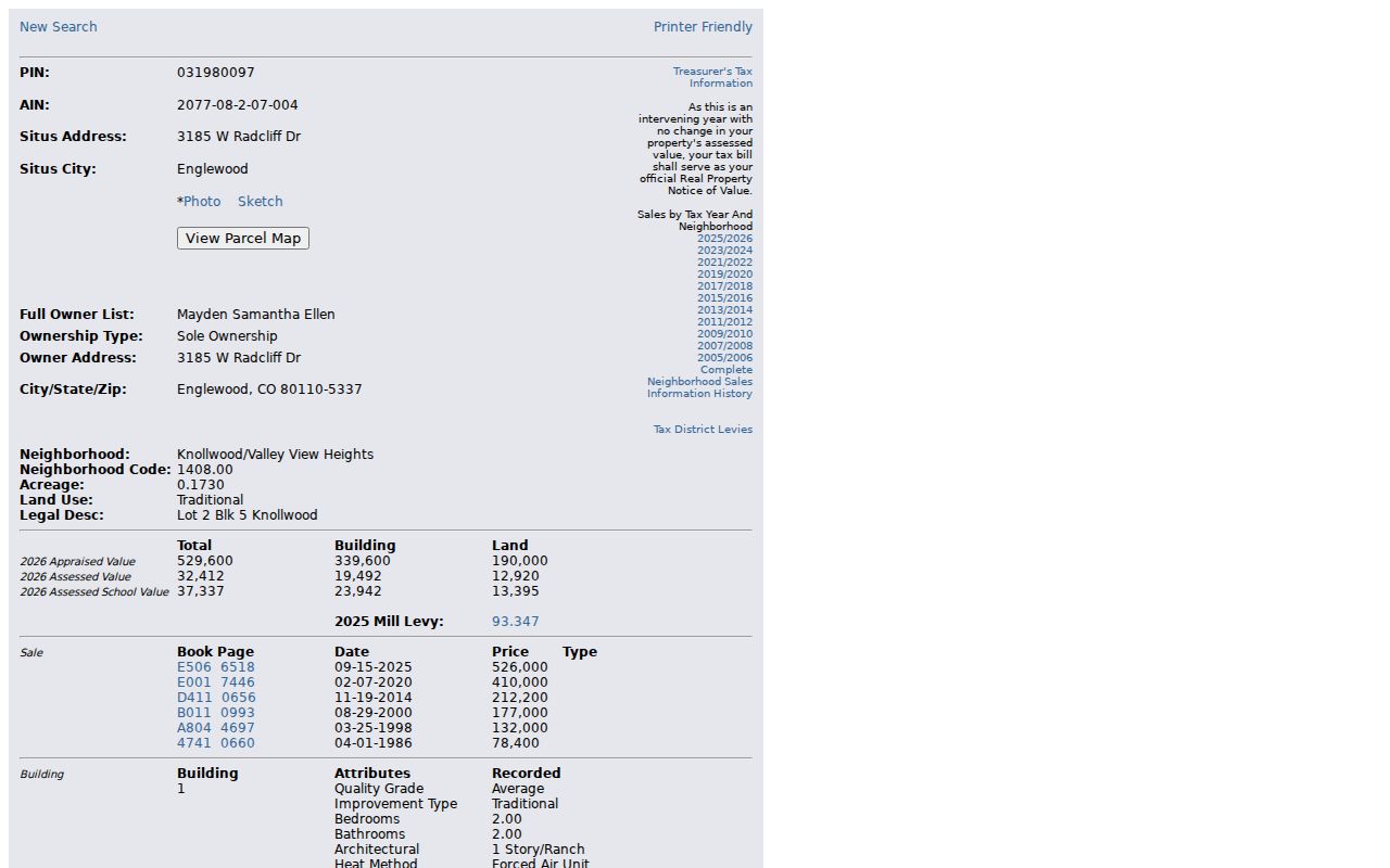
A public assessor sample for Englewood showed how much a parcel result can contain without becoming a person profile. The inspected record used AIN 2077-08-2-07-004 and returned PIN 031980097, situs 3185 W Radcliff Dr, ZIP 80110-5337, Knollwood/Valley View Heights, neighborhood code 1408.00, 0.1730 acres, Lot 2 Block 5 Knollwood, 1962 build year, and a single-family residential classification. The research notes intentionally omit the named owner.
The same sample showed a 988-square-foot first floor and total building area, basement and garage fields, deck and porch fields, roof and exterior information, and 2026 appraised and assessed values. These numbers are a field model, not a reason to infer a household. County disclaimers warn that measurements, photos, and sketches may not be complete. Preserve the parcel’s date, classification, and source URL before comparing it with a deed, tax account, sales dashboard, or GIS layer.
The sample Englewood parcel result demonstrates the county’s public field layout with the owner name omitted from the research record.
- Parcel
- The county’s mapped tract, identified by a PIN or AIN.
- Situs
- The physical-location label attached to the assessment record.
- Plat
- An official map or recorded plan that lays out lots, blocks, streets, or boundaries.
- Criss-cross directory
- A reverse address or phone tool tied to a particular publication year.
Reverse Directories as a Dated Street Tool
The regional directory shelf can fill a gap between a deed party and a current parcel. Denver Public Library index entries describe 1932 and 1939 western Arapahoe or suburban volumes, plus 1969, 1970, 1971, and 1975 Polk’s Denver Suburban examples. The 1970 description includes an alphabetical city directory, buyer’s guide, classified business section, street and avenue guide with phone, and numerical telephone components. Search Englewood, western Arapahoe County, Littleton, Sheridan, and broader Denver suburban labels.
A reverse entry may point from a street or telephone number to a household listing. Treat it as a dated publication, not a living roster. Compare the printed street form with the deed legal description, a newspaper date, or a Sanborn block. The complete Englewood run and a public scan of a specific entry remain research gaps. The historical collection itself belongs with the Englewood city directory collections, while current address-keyed work stays in the street directory lane.
Limits on an Englewood Street Directory
An address record may identify a parcel, instrument party, project, or dated listing. It may not show every household member, a private customer record, a protected voter address, or a person’s current relationship to the location. Motor-vehicle address information is restricted under the Driver’s Privacy Protection Act. Vital records are confidential, and court or registry records can be sealed, redacted, dynamic, or limited.
Lawful personal use. Englewood street and address records support family history, place research, and ordinary civic curiosity. Do not use them to stalk, harass, intimidate, or harm anyone.
When a match is uncertain, keep the uncertainty. Record the source, custodian, date, search key, and field that supports the link. A correct street directory is a set of dated, qualified records, not a list of names stripped from their context.